Popular destinations nearby
Székesfehérvár,
Tata,
Tatabánya,
Bakonybél,
Dunaújváros,
Eplény,
Gárdony,
Komárom,
Pápa,
Várpalota,
Velence,
Zirc,
Ajka,
Alcsútdoboz,
Ászár
|
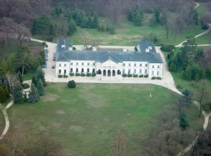
The name of the village probably refers to the starlings which used to fly around the herds of cattle and the flocks of sheep: the word 'seregély' was given the suffix - es. It is also important to note that these birds used to be caught by professional fowlers, so the name of the village might preserve the name of a profession, that of people catching starlings. Geographically it is situated in Middle-Mezőföld region, with a landscape typical of the Great Hungarian Plain. Its surface is made varied by the loess ridge stretching as far as Paks, the valley Háromág of tectonic origin and the territory of the one-time tongue of Lake Velence. Naturally the variety of the surface is shown by the fauna and the flora, too. Rare plants and animals can be seen in the loess and the wet meadows, in the moorland and in the Mansion park, as well. The history of the village goes back to the Roman times. At the southern border of the city a large villa farm and a burial place, in which a carriage was also put in the grave with the dead body, were excavated. In Hungarian history it was originally a royal property, where the people of the castle of Fehérvár and royal stablemen lived. It was first mentioned in records in 1258, when the predecessors of counts Eunordi Szolgagyori, namely royal chancellor Prépost of Fehérvár and his brothers, counts Vilmos and Egyed founded the monastery of Zsámbék and Vilmos was donated half of the land and pasture called Ságh and Seregélyes. The donation was approved by King Béla IV. The village had several landowners from 1345 to the end of the 17th century. During the Turkish rule it belonged to Hussein Bin Abdullah. In 1696 it was mentioned as the property of Pál Zichy. The church of the village was built in 1735 and it was rebuilt in 1792. The neo-classical mansion in the park of the village was built by the Zichy family in 1821. The building was probably designed by Mihály Pollack, the frescoes in the banquet hall were painted by Ferenc Pich. During the war of independence of 1848-49 Seregélyes served as a base of operations. (29 September 1848 - Battle of Pákozd). The village had peaceful life until World War II, but it suffered a lot during the war. From 8 December 1944 to 23 March 1945 it was an area of operations and the ownership of the village changed seven times. The most severe war was fought during the last German fights in Hungary. After the war and the period of reconstruction, Seregélyes started to develop, too. This was due to the development of agriculture as well as the industrialization of Székesfehérvár. The latter still plays an important role in the employment of the locals. A lot of the inhabitants deal with agriculture, too, either in the reclaimed land or in large farms. The patronal saint of the village is St. Florian. The Pelikán-house Forest school is situated on the edge of Dinnyési marsh, providing continuous bird-watching possibilities to the campers. This activity is very popular with visitors along with the ringing of the birds by professionals. Within easy reach (maximum 20-30km) you can find protected areas such as the Bird Reserve of Velence, the Rocking stones of Pákozd, the arboretum, the bee-eaters' site, the quartzite rocks of Pázmánd, the Nature Conservation Areas of Sárrét, Sárvízvölgy, East- Bakony, Vértes. These protected territories can be visited only with professional guides. Pictures of Seregélyes
|
Seregélyes map nagyítása >>
|
|
|
Hungary - Seregélyes |
|
|
|
||
|
Saturday, 27. June 2026. - 18:55:08 |
||